Monday, July 19, 2010
Well, sadly, the extended vacation draws to a close, and along with it I suppose, this blog. I’ve had a lot of fun writing it. Oh, and I think I’ve fixed the posting feature now, so feel free to post some comments if you like….particularly if they are flattering in some way! Even though the vacation’s end draws nigh, we have still managed to do some pretty exciting things. I have some pictures posted here and on my Facebook page, but for more and better pics, you should really check out Mariel’s Facebook page.
This blog is late in coming, sorry Mom, but it includes two weeks instead of one. Sadly, after two successful months of eluding him, Moctezuma finally found me and exacted his revenge. I was being so careful...but it wasn’t so bad, no real loss except perhaps a kilo which I could easily afford, and a day in bed. Unfortunately, we did miss Alejandro’s birthday/karaoke party, which I really wanted to go to, a birthday, by the way, which he shares with the city of La Paz…so happy birthday to you both. La Paz is now 201. I’m not sure how old Alejandro is, but I’m awfully sorry to have missed what I am sure was a lot of fun.
As most of you probably know now, Mariel and I have decided to stay in La Paz for the next year. After some twist and turns throughout the labyrinths of government officials, rules, and regulations, of both countries, we determined the best course of events for us would be to stay here for year. That changes a lot of plans…the wedding scheduled for September in Virginia has changed to October in La Paz for one. We still plan a great ceremony back in Virginia when we return, so please keep us penciled in to your plans…just on the next calendar. I have found a job teaching English here in La Paz and will return to the US at the end of this month to settle some things. It is an actual job, not just juggling on Calle 25 for spare change, which was my first option. A big HUGE thank you to everyone on both sides of the family for all the help, both logistical and emotional, in regards to this change. We never saw this change of events coming, but it is exciting and we are looking forward to the next step. Ultimately, we’ll be back in the U.S., I don’t think I can stay away from 5 Guys Hamburgers for too long.
So, I may continue with the blogging, but just talking about work would probably get pretty boring after all the excitement of the last two months. We’ll see. But with that said…
On July 8th, Mariel and her mother took me to a very beautiful section of La Paz called Valle de las Ánimas, or the Valley of Souls. The geography was spectacular. We drove basically to the base of Mt. Illimani, and it’s immensity from this perspective was overwhelming to say the least.
Illimani
The snow caps made clouds appear just over its tallest peak and we got a view of Illimani’s sibling peak, Mururata. Well, peak is not really apt…it is a peak I suppose, but it is flat compared to Illimani. Legend tells us that at one time Mururata was the taller, sharper peak, but younger and jealous Illimani took a sling and with a massive boulder, decapitated his older, taller brother, leaving a smaller, more rounded Mururata. The geographic features of the Valle de las Ánimas are pretty incredible. It reminded me of the Roadrunner cartoons…some of the boulders on top of the sandy towers seemed to defy gravity in much the same way. We saw several black falcons swooping from their nests to check us out. I lost my sunglasses arm, and miraculously, Mariel found it for me…Over all, it was a pretty cool place. It had a rustic, country feeling and just minutes from the city.
The next big adventure was our visit to Lake Titicaca. Mariel, her mother and father, and I left the morning of the 13th for a beautiful drive to Copacabana, and yes the Barry Manilow song was running through my head…even thought that’s a different Copacabana of course. We drove up from Zona Sur, up and through El Alto and out into “the country,” country that is fast becoming engulfed by the rapidly expanding El Alto, but we passed several adobe huts and houses and numerous farms. We went up and over several mountains and after about an hour, Sr. Percy told me to look to my left, and peaking through a gap between two mountain tops I saw Lake Titicaca.
It was like a dark blue gem glistening between the yellow grassy mountains. It was utterly beautiful. As we drew closer, it seemed to expand and the horizon was lost; it was so large it looked like the ocean, but flat and tranquil. It glistened in the morning sunlight reflecting the sun, but seeming really to absorb the blue of the sky into its own dark, rich blue. Amazing.
Click on the pictures to make them larger.
Titicaca is one of the world’s highest lakes, and the largest lake in South America. The lake is both in Peru and Bolivia, according to Mariel it’s 51% Bolivian and 49% Peruvian. Also I have heard that Bolivia has the Titi ,and Preu has the Caca…but something tells me that joke is told differently in Peru.
When I tried to find out about the name I found that no one really knows the name’s orgin, but using the languages of Quechua and Aymara (the languages of the peoples from this area) it could mean “Crag of Lead” or “Rock Puma.” Some believe the Rock Puma name is most believable because from above the shape of the lake does somewhat resemble a puma hunting a rabbit. The lake also has several islands popular with visitors: Isle of the Sun (a sacred Inca island) and Isle of the Moon just to name two; there are about 40 others. Mariel and I plan to visit some of these soon. Interestingly enough it is also where the land-locked Bolivian Navy does its marine exercises.
In order to get to Copacabana we had to cross the lake on a Ferry, about a ten minute ride. We were able to get out of the car and take a few pictures.
View of Illimani and Murauata in the distance from the ferry
A very well-balanced dog on one of the ferries
Crossing on the Ferry
From this angle I was able to see the other side of Illimani. It’s beautiful from both sides. Then we drove up again and soon we descended toward the town of Copacabana; we could see it easily from the tall mountain pass nestled quietly on the shore of Titicaca.
Copacabana from the road; that's Al Calvario on the right.
Dominating the geography of the town is a giant hill now called El Calvario, or Calvary. The town itself contains the large, very beautiful, 16th century shrine Basilica of Our Lady of Copacabana, the patron saint of Copacabana. But it was a sacred place even before the Spanish, a distant outpost of the Inca it is believed to be a place where there lived a fertility god Kotakawana, the Aphrodite of Andean mythology. The Basilica is supposedly built upon an older temple dedicated to Kotakawana. If the usual modus operandi of the Spanish is true for Copacabana holds, this could be true. There is also the theory, if Wikipedia is to be believed, that the town’s names comes from the Aymara word Kota Kahuana, or view of the lake, but I haven’t verified this. Sounds plausible. Either way, it is a very beautiful place. Being there you can feel a deep spirituality.
Mariel and her mother and I climbed the tall hill/mountain called Calvary.
At the start
It is more of a spiritual walk that echoes the footsteps of Christ, with 14 stops and ending at the top with an amazing view of the town below and the surrounding lake.
About half-way
It wasn’t easy, but the view and feeling from the top made it worth the trouble. At the top, and on the way up, are several shrines and spiritual places. It is interesting to see the incorporation of traditional and Christian religions. We even passed one family and shaman performing some ritual; I was curious, but I didn’t want to be rude and stare. I have no idea what the ritual was for, but I did notice it included the use of firecrackers and lots of smoke.
Once we enjoyed the view and took some pictures it was time for the walk back down…equally difficult but a bit faster.
Pinching Mariel's car from about half-way up.
And when we got back to car it was definitely time for some lunch. We cruised around town for a bit taking in the views and vendors. There were lots of little stands with very interesting crafts, food, and gifts. We eventually found a restaurant where we enjoyed what I had been anticipating all day: Lake Titicaca Trucha. Fresh Trout!
OMG…I was not disappointed. Mariel and her family were right. The fish was outstanding. Then with our bellies full we walked a bit more and did a bit of shopping, then headed home, full, tired, and satisfied. We crossed on the ferry again and looking out I could see the Lake reflecting the sun in its deep, dark-blue depths. A truly, incredibly beautiful place.
Enjoying some Api...who knew you could make drinks from corn that aren't Alcoholic?!
After the fantastic visit to Copacabana, we rested a day or so and Mariel took me to central La Paz to see Plaza Marillo. Here is where you find the governmental center of Bolivia, and if you travel from here in any direction the Kilometers are measured starting from here. Here was where I finally got to see my first official “march” or protest. I’m not sure what they were protesting, but it was noisy and chaotic and pretty interesting to watch.
A protest march. I'm the tall one in the forground with the baseball cap:)
But more importantly, it’s here they have the “Witches’ Market.” Here you can buy most anything from Coca leaves to shrunken llama fetuses, good luck talismans and various herbs and potions for whatever ails you.
At the Witches' Market.
It was interesting to see, and smell, but very hard to describe. The roads are steep and cobblestone, the sidewalks are steep and narrow, so waking requires paying attention, yet at the same time, you want to look all around. So the tourists are easy to spot as they are the ones stumbling around looking in all different directions. I was one of them. But fortunately Mariel was there to help me along and do all the talking and negotiating…and she knew where she was going. That helps a lot! Poor Mariel has done a lot of translating and interpreting since I've been here. We've really kept her brain busy. And she has done it all without a minute of complaint. I don't know how she does it.
So, all in all, another very exciting couple of weeks. In another week, Mariel’s mother, Wecky, and I will travel back to Charlotte, and the vacation portion of this trip will sadly be over. But it certainly has been fun. Fun is such a small word to cover it…really, it has been the trip of a lifetime. One more food blog to go I think, and after that I’ll have to keep you posted. Check out our facebook pages for more pics if you are interested. Thanks for reading!
From the top of Calvary
Chau!
Monday, July 19, 2010
Wednesday, July 7, 2010
Peru, Cusco, Machu Picchu
July 7, 2010
Wow! What a trip we had! We left La Paz for Peru on July 1st and found ourselves in Cusco a short time later. From the plane I was able to see the sharp contrast of the different landscapes. Where La Paz resembles what I imagine to be a moon-like landscape, the mountains peak in jagged, pointy angles, as we flew westward toward Cusco, the mountains seemed to smooth out a bit, resembling from the air the look of a bunched-up carpet much darker than the sandy colored mountains of La Paz. Always in the distance lingered the snow-capped chain of the Andes. For only an hour long flight, the change in landscape was astounding. The height of the mountains remained roughly the same, so coming from La Paz, I didn’t suffer the altitude sickness that affects so many travelers to Cusco. All the same, I had some Coca tea at the hotel to counter any ill effects of sorojchi, or altitude sickness.
But all was bien!
We didn’t waste any time and immediately after the tea, started to explore Cusco. We made our way first down the Avendia Sol, or Avenue of the Sun, to the Plaza de Armas, sort of the central square of the city. Here they have many shops and merchants selling wares. And you really have to hand it to those sellers; they get an A+ for persistence. They really try hard to sell things. It was here I perfected my pronunciation of “No, Gracias.” But talk about not taking NO for an answer. If we had stayed just one more hour, I would have bought something; they were wearing down my resistance.
In the Plaza de Armas there is a Spanish cathedral, The Basílica Catedral, and three smaller “churches," Iglesia de la Sagrada Famila, (church of the Sacred family)
Inglesia de la Sagrada Famila
and Iglesia del Triunfo, (church of the Trinity or Triumph), and Templo de la Compañia (accompanying temple) that dominate the square. These were of course built atop older, Inca temples. Cusco originated as an Inca city, perhaps the capital of the Inca civilization. The city itself seems built atop Inca ruins. Many places still use the foundation of Inca architecture.
The Inca architecture itself is amazing, big stones fit together tightly without mortar, a skill that defies logic and understanding to this day. How did they do it? We have no answer to this, but each stone is laid one atop the other perfectly matching and fitting together, practically seamlessly. Each seam is convex/concave and they have remained intact for over 500 years. The blocks they used, some weighing over 150 tons, are impressively cut and manicured to fit the natural shape of the stone around them. Perhaps one of the most impressive is the La Piedra de los 12 Angulos, (the stone of 12 angles). Check out the picture. (If you click on them they get bigger)
Piedra de los 12 Angulos
How the Inca accomplished this is beyond understanding. Perhaps it really was alien technology!!!!
After eating some delicious food and exploring the city, we toured the Cathedral and surrounding churches. It was the first of many interesting tours. As long as I’m handing out A+s, the tour company we had was really well run. They managed us most impressively, and the things and places we saw seemed to increase in impressiveness ending with the trip to Machu Picchu. It was really well planned. They do a good job. We learned a lot about the history of the Spanish and their conquest over the Inca as they attempted to impose religion and in the process take all the gold they could find. Their methods were, by today’s standards, cruel, inhumane, and effective. They accomplished the destruction of the Inca Empire in just a few short years, the first of which there was peaceful cohabitation (1533-35). By the 1600s there was very little left of the history and ingenuity of the Incas. Same story of European conquest we get in most of the New World, but here in Peru, the Incas rivaled the Romans in their ability to plan and build a city and run an Empire that stretched the breadth of South America. So quick was the destruction that several of the temples remain unfinished. Machu Picchu was however preserved in some sense because the Spanish never found it. Still, it was in the building stages when, for some mysterious reason, it was abandoned…perhaps the Spanish, perhaps disease…we are not even really sure what its purpose was, defense? Residence? Astronomy? One of the latest theories was that it was perhaps a sacred center of learning…the first Inca University perhaps? The mystery surrounding Machu Picchu is one of the most interesting and frustrating parts of the city. But I get ahead of myself and our tour.
After visiting the Cathedrals, we went deeper into Cusco to Qorikancha, what is believed to be a sacred temple of the sun for the Inca. The Spanish descriptions tell of a temple covered in gold plating, with life-size golden statures of different animals adoring the gardens. Now, built on the foundations is the Convent De Santo Domingo. It was here we got our first lesson of the incredible architecture of the Inca and got a good look at the amazing stone foundations.
The Sun Temple/Convent de Santo Domingo...notice the Inca foundation and walls.
From there we visited several other Inca sites, too many to show pictures…please check out Mariel’s Facebook page for all the pictures.
The next impressive place was Saqsayhuaman, pronounced (for the Americans) like “sexy woman.” The word actually translates into something like, the satisfied falcon or vulture. This was a huge Inca fortress/temple/citadel. According to the guides it must have taken 150 years or so build. It contains tremendous stone boulders, some weighing as much 150 tons. It was here in the late 1500s that the Incas began their ill-fated revolution against the Spanish. It was doomed from the start as a lack of an army, and mechanisms of war hindered the Inca, and hundreds of thousands were wiped out in one battle. There were so many dead Inca Saqsayhuaman earned its eerie name.
The area is several hundred acres and built on three levels, representing the three levels of the universe according to the Inca tradition. Hana Pacha, or the heavens (represented by the condor), Uku Pacha, the underworld (represented by the snake), and Kay Pacha, or Mama Pacha, our world or the earth, (represented by the Puma.) There are several other symbols that represent the same, and it is apparent the Inca had several gods and spirits that controlled and manipulated the universe. However the reoccurring symbol of the three worlds seems ubiquitous to all the temples/ruins we visited. From here, we were able to see a great vista of Cusco. The ruins light high above the city and have breathtaking views.
Saqsayhuaman.
Mariel and I infront of the 150 ton stone...How'd they do that? Notice how the stones fit together without mortar.
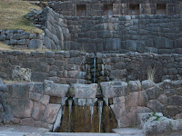
After Saqasayhuaman, we visited Tambomachay, or the resting place. Here there are several ruins that are sort of an aqueduct, with water still flowing. According to legend it is a place like the fountain of youth. However, Mariel tells me that a friend of hers drank some of the water and spent the remainder of their vacation sick in bed with typhoid…sooo…I didn’t risk it. But it was equally beautiful and it was interesting to see how they were able to use the shape of the surrounding earth and their own architecture to support the land and crops.
Tambomachay
With a quick stop at Qenqo, a cave like structure where it is presumed that pre-mummification took place, we proceeded back to our hotel. At Qenqo there is an interesting stone monument which, when the sun hits it correctly, casts a shadow of a puma. Then back to Cusco for a late dinner and some sleep after a tiring day.
Then next day was spent touring several other sites sacred to the Inca. One Inca palace had a Spanish church built on top of it. We proceeded down into the Sacred Valley of the Inca.
The Sacred Valley
This valley is a rich farming zone that follows the rio Aguascalientes, (hot water), a very special place to the Inca with lots of terraced farming land still in use today. One very interesting place, also an unfinished temple/fortress/palace, we visited is called Ollantaytambo.
The Ollantaytambo terraces
This was the first place to challenge our stamina, a tall, terraced fortress that scaled up a mountain in the small village of Posada. Here we were able to walk up to the top of the structure and see the village below. We could see the gigantic stone monuments making up the unfinished temple which came from the mountain across the valley. Again, how in the world did they manage? Our guide told us to imagine them working like ants to pull and push the humongous stones and eventually lay them in place. Again, this fortress remained unfinished for what reason? We may never know. From the top of the temple grounds we could see across the valley a natural rock formation called the profile of the Inca.
Profile of the Inca (look closely at the center of the picture)
The profile is natural, but if you look closely you can see they crowned the face on top with a stone tiara. To either side of the profile you can see storage buildings for the food and crops grown in the valley below. Carrying the food up there must have been no easy trick.
The next day, July 3, we awoke at 3:15 a.m. in order to take a two hour van ride to the town of Ollantaytambo where we caught a train for a one hour and fifty minute ride to the town of Aguas Calientes, point of departure for Machu Picchu. The train ride was amazing with views of agricultural terraces and ruins, and basically if followed the path of the Inca trail. Once In Aguas Calientes we boarded a bus that took us up a windy, curvy, and let’s call it like it is…friggin scary ride up the mountain to Machu Picchu, much scarier than the Death Road. I closed my eyes for some it, I admit…But the jungle terrain was incredible; we were able to see the terrain change from the rather barren mountains of Cusco to the dense growth of the Machu Picchu valleys as we descended some 4000 feet. Then up, up, up the scary road to Machu Picchu. It was about a 30 minute bus ride and we entered the park. We walked through a tunnel type opening in the crack of the mountain, and on the other side, Machu Picchu exploded into view. I can’t describe it. I was stunned, awed, shocked, impressed, flabbergasted, amazed, and swooning with vertigo.
First Look at Machu Picchu
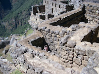
Why did they build the city on the top of the mountains? Why did they leave before it was finished? What was the purpose? There are living quarters, agricultural areas, temples, an astronomy observatory…we think. Was it a center for education? Clearly it was very important, and as the Inca trail leads directly to it, it was meant to be visited. I would love to know the answers to some of these questions, but it all adds to the incredible mystery of the place. Walking around there you can feel the different energy. Even after the long, tiring trip to get there, we were invigorated to climb to the top and explore the amazing houses and aqueducts, temples and observatory. We arrived about an hour before our tour guide so we had a chance to explore by ourselves and take pictures. I only have put a few here, and I would encourage you again to see Mariel’s facebook page for many more, plus some descriptions. It was, simply, awe-inspiring. I’ve never experienced anything like it. The whole time I was there I had to keep looking and reminding myself that I was actually there. All my life I’ve wanted to visit and it was hard to believe I finally was.
Once the tour guide found us we were able to get some explanations for what we were seeing, explanations, or guesses, or hypothesis because so much is unknown. What little we do know is that it is one city that the Spanish didn’t find. An American explorer, Hiram Bingham, “discovered” the city and began the clearing process with the help of the National Geographic. Actually Bingham heard about the area and paid one Sole, about 10 cents, to a local farmer to show him where it was. That was back around 1912. Most of what we know about it comes from Bingham’s speculation, some of which has been rejected by archaeologists today. Look at the picture of the Sun Temple…the rounded structure...
notice how fine the stone work is compared to the stone work of the priest’s house to the left, and that is even finer stonework than the storage houses and the farmer houses below…according to the tour guide the better the stonework, the more important the building…thus the temples and observatory are very important.
Storage Places
An unfinished temple
In the observatory, there is a stone, like a great sundial, but not so much for telling the time of day but the time of the year. It corresponds with the sunrise on the solstices, important for planting purposes. Well, I could go on and on and on…I think I already have. I’ll shut up for now, but there are a lot of interesting tidbits and facts and guesses we could make. Google Richard L. Burger at Yale University if you really want to know more about Machu Picchu. All I can tell you is it is a magical, mythical, beautiful place. And I want to go back!
Ok, shutting up now…more adventures to come. Check back.
Chau!
Subscribe to:
Posts (Atom)